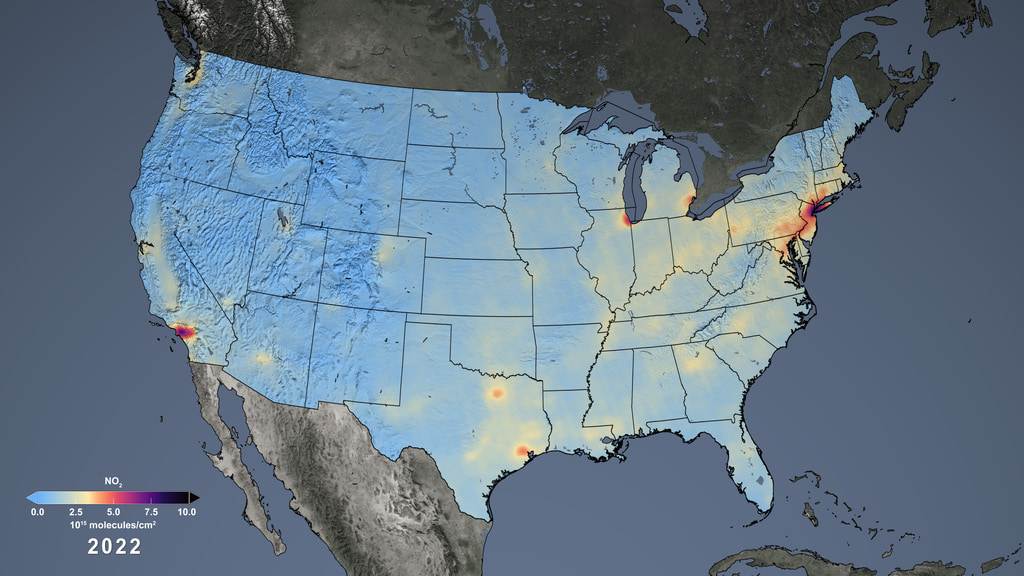
NASA satellite data adds key pollutant to national environmental justice database
The integration of NASA satellite data into national environmental justice efforts represents a major leap forward in understanding air pollution’s impact on marginalized communities across the United States. Nitrogen dioxide (NO2), a harmful pollutant primarily released from fossil fuel combustion, had long been absent from the EPA’s Environmental Justice Screening and Mapping Tool (EJScreen). By incorporating high-resolution satellite measurements from NASA’s Aura satellite, this pollutant is now mapped at detailed neighborhood levels, allowing for more precise identification of areas burdened by poor air quality. This article explores the significance of this development, the technology behind it, and its implications for public health and environmental equity.
Understanding Nitrogen Dioxide and Its Health Impacts
Nitrogen dioxide (NO2) is a toxic gas produced mainly from burning fossil fuels such as coal, oil, and natural gas. Common sources include vehicle emissions, power plants, and industrial processes. As a major component of urban air pollution, NO2 contributes to the formation of smog and acid rain, significantly affecting environmental quality.
Exposure to elevated levels of NO2 has been linked to a range of respiratory issues, including asthma, bronchitis, and reduced lung function. Children, the elderly, and individuals with preexisting respiratory conditions are particularly vulnerable. Prolonged exposure can exacerbate chronic diseases and increase hospital admissions related to respiratory illnesses.
Despite its known health risks, NO2 data had been notably absent from key national environmental justice databases, limiting the ability to identify communities disproportionately affected by this pollutant. Including NO2 measurements is critical for developing targeted policies to improve air quality and public health outcomes.
NASA’s Aura Satellite and the Ozone Monitoring Instrument (OMI)
NASA’s Aura satellite, launched in 2004, carries the Ozone Monitoring Instrument (OMI), a sophisticated sensor designed to monitor atmospheric gases and pollutants globally. OMI detects trace gases such as ozone, nitrogen dioxide, and sulfur dioxide by measuring sunlight reflected from the Earth's surface and atmosphere.
With over two decades of continuous data collection, OMI has provided invaluable insights into air quality trends and atmospheric chemistry. Its ability to capture data at a high spatial resolution—down to approximately one kilometer—allows for detailed mapping of pollutant concentrations across urban and rural landscapes.
The satellite’s vantage point from space enables it to detect pollution patterns invisible to ground sensors, offering a comprehensive and unbiased view of air quality that is essential for environmental monitoring and policy making.
Filling the Data Gap in Environmental Justice Screening
The Environmental Justice Screening and Mapping Tool (EJScreen) is an EPA-managed platform that combines environmental and demographic data to identify communities facing disproportionate environmental burdens. Until recently, NO2 data were missing from this tool, creating a significant gap in assessing air pollution exposure risks.
NASA’s collaboration with the EPA and academic partners allowed for the integration of OMI-derived NO2 measurements into EJScreen. The data were processed and averaged at the census block level, providing localized insights into chronic NO2 exposure that were previously unavailable.
This integration enhances EJScreen’s capability to highlight vulnerable neighborhoods, factoring in both pollutant concentrations and socioeconomic variables such as income, race, and language proficiency. The updated tool now offers color-coded maps that visually communicate pollution burdens in an accessible way.
The Collaborative Effort Behind Data Integration
Incorporating NASA’s satellite data into a national environmental database required extensive collaboration among federal agencies, universities, and research institutions. Scientists from NASA, the EPA, George Washington University, and other partners worked together to validate and process the satellite measurements for use in EJScreen.
One key challenge was translating the raw satellite data into formats suitable for community-level analysis. This involved averaging NO2 concentrations over census blocks and ensuring the data aligned with existing demographic and environmental datasets.
The collaborative effort not only improved the accuracy of environmental justice assessments but also democratized access to complex air quality data, enabling policymakers, researchers, and community advocates to make informed decisions based on high-quality information.
Implications for Communities and Environmental Justice
Marginalized communities often face higher exposure to air pollutants due to proximity to highways, industrial zones, and transportation hubs. The inclusion of NO2 data in EJScreen provides a clearer picture of these disparities, helping to identify neighborhoods where residents face compounded environmental and social challenges.
Community organizations and advocacy groups can now leverage this data to strengthen their campaigns for cleaner air and improved health protections. For example, localized NO2 maps can inform urban planning decisions, traffic regulations, and pollution control measures tailored to the needs of vulnerable populations.
By highlighting environmental injustices with precise data, the updated EJScreen supports equitable policy development, ensuring that resources and interventions are directed to communities most in need and fostering greater environmental equity nationwide.
The ability to monitor air pollutants from space marks a significant advancement in environmental science. Satellite instruments like OMI provide consistent, global coverage that complements ground-based monitoring networks, offering a more complete understanding of air quality dynamics.
Emerging satellite technologies continue to improve spatial resolution, temporal frequency, and pollutant detection capabilities. These innovations promise even more detailed and timely data for environmental justice assessments in the future.
Integrating satellite data with machine learning and geographic information systems (GIS) further enhances data analysis, enabling predictive modeling and real-time monitoring that support proactive environmental management and rapid response to pollution events.
Future Directions and Policy Impact
The successful integration of NO2 data into EJScreen sets a precedent for incorporating additional pollutants and environmental indicators derived from satellite observations. This can expand the scope of environmental justice tools to address a broader range of health risks and environmental stressors.
Policymakers can utilize the enriched data to design more effective regulations, allocate resources efficiently, and track progress toward national air quality and equity goals. Transparent, accessible data also empower communities to participate actively in environmental decision-making processes.
Looking ahead, continuous collaboration between space agencies, environmental regulators, and researchers will be essential to maintain and enhance data quality, ensuring that environmental justice initiatives remain grounded in the most accurate and comprehensive scientific evidence available.
Conclusion
The incorporation of NASA satellite-derived nitrogen dioxide data into the EPA’s Environmental Justice Screening and Mapping Tool represents a transformative step in environmental monitoring and justice. By providing detailed, accessible information about pollutant exposure at a neighborhood level, this advancement empowers communities, policymakers, and advocates to address air quality disparities with greater precision and urgency. As satellite technology evolves and collaborations strengthen, the integration of space-based data will continue to enhance our ability to protect vulnerable populations and promote healthier, more equitable environments across the nation.
Originally reported by space.com. Adapted for our readers.
Author of the article: Published Sep 18, 2026 11 minute read Article content Kyndryl Canada has been engaged to deliver a commercialization strategy and…
The National Agency for Science and Engineering Infrastructure (NASENI) on Friday 4th September 2026, marked three years of institutional transformation under its Executive Vice…
Municipal Administration Minister P. Narayana speaks to residents after laying the foundation stone for the slum redevelopment project at Velampeta, near Lakshmi Nagar in…