NASA ISRO radar satellite beams first Earth images from space
In a landmark achievement for international space collaboration, the NASA-ISRO Synthetic Aperture Radar (NISAR) satellite has beamed back its first high-resolution radar images of Earth from space. Launched on July 30, 2025, by the Indian Space Research Organisation (ISRO), NISAR is the most advanced Earth-observing radar satellite ever developed, combining sophisticated radar instruments from NASA and ISRO. These initial images mark the beginning of a new chapter in Earth science, promising unprecedented insights into natural hazards, environmental changes, and agricultural monitoring. This article delves into the technology behind NISAR, the significance of its first images, and the mission’s anticipated contributions to global Earth observation.
The Genesis of the NASA-ISRO Partnership
The NASA-ISRO Synthetic Aperture Radar (NISAR) mission is the result of a long-standing and strategic partnership between the United States and India. This collaboration brings together NASA’s expertise in radar technology and ISRO’s proficiency in spacecraft development and launch capabilities. The joint mission exemplifies how international cooperation can maximize resources and scientific returns for mutual benefit.
Initiated nearly a decade ago, NISAR was designed to leverage the strengths of both agencies. NASA developed the L-band radar system, while ISRO contributed the S-band radar, spacecraft bus, launch vehicle, and mission operations. This synergistic approach allowed the mission to incorporate dual-frequency radar instruments, a first in Earth observation satellites, enabling enhanced data quality and versatility.
The collaboration also extends to mission operations and data sharing, with teams from NASA’s Jet Propulsion Laboratory (JPL) and ISRO’s U R Rao Satellite Centre, Vikram Sarabhai Space Centre, and Satish Dhawan Space Centre working closely. This cooperative framework ensures that NISAR’s data products will be accessible to scientists and policymakers worldwide, fostering global scientific advancements.
Advanced Radar Technology Behind NISAR
NISAR carries two synthetic aperture radar instruments operating at different frequency bands: L-band and S-band. NASA developed the L-band radar, which uses longer wavelengths capable of penetrating dense vegetation and measuring ground movements with remarkable precision. This radar can resolve surface features as small as five meters, enabling detailed monitoring of geological and environmental processes.
ISRO’s S-band radar complements the L-band by operating at shorter wavelengths, ideal for detecting smaller vegetation and providing detailed observations of crops and grasslands. The dual-frequency capability is unprecedented in Earth observation, allowing NISAR to distinguish between different types of land cover and to capture dynamic changes in ecosystems.
The satellite’s 12-meter drum-shaped antenna reflector is the largest ever launched by NASA, enhancing radar sensitivity and image resolution. Operating from an altitude of 747 kilometers, NISAR can revisit the same location every 12 days, providing consistent, high-frequency data essential for tracking changes over time.
First Images: A Glimpse of NISAR’s Potential
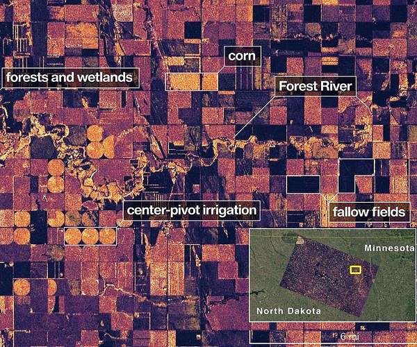
In August 2025, NISAR transmitted its first radar images, revealing detailed views of Mount Desert Island in Maine and agricultural regions in North Dakota. These preliminary images demonstrated the satellite’s extraordinary ability to differentiate between forests, waterways, farmland, and human-made structures, highlighting its capacity for detailed Earth surface mapping.
The images showcase the satellite’s proficiency in penetrating forest canopies to measure soil moisture and ice movement with sub-inch accuracy. Such precision is vital for monitoring natural hazards like earthquakes, volcanic activity, and landslides, as well as assessing seasonal crop growth and water resources.
These initial snapshots provide a preview of the comprehensive datasets NISAR will generate once full science operations commence. Scientists anticipate that this data will revolutionize understanding of Earth’s dynamic systems and improve predictive models for natural disasters and climate change impacts.
Applications in Natural Hazard Monitoring
NISAR’s radar technology is uniquely suited to detecting subtle changes in Earth’s surface, making it a powerful tool for natural hazard monitoring. Its ability to track ground deformation with millimeter precision allows for early detection of earthquake precursors, landslides, and volcanic activity, potentially saving lives through timely warnings.
The satellite’s frequent revisit time ensures that changes can be monitored continuously, providing near-real-time data to emergency response teams and governmental agencies. This rapid data turnaround is critical for disaster preparedness and response, helping to mitigate the impacts of natural catastrophes.
Moreover, NISAR’s capacity to penetrate cloud cover and operate day or night ensures consistent data acquisition regardless of weather or lighting conditions, overcoming limitations faced by optical imaging satellites. This reliability enhances its role as a cornerstone in global disaster monitoring networks.
Contributions to Agriculture and Ecosystem Management
Beyond hazard monitoring, NISAR’s dual-frequency radar system offers valuable insights into agricultural practices and ecosystem health. The S-band radar’s sensitivity to small vegetation allows for detailed crop monitoring, including growth stages, biomass estimation, and stress detection caused by drought or pests.
Farmers and agricultural policymakers can leverage NISAR data to optimize irrigation, improve yield forecasts, and implement sustainable farming practices. This satellite-based information is especially crucial in regions where ground-based monitoring is limited or unavailable.
Additionally, NISAR’s L-band radar can assess forest biomass and soil moisture, contributing to better understanding of carbon cycles and ecosystem dynamics. These data support global efforts to combat climate change by informing conservation strategies and land management policies.
NISAR’s Role in Climate Change Research
Climate change is reshaping Earth’s landscapes, and NISAR’s comprehensive radar observations are poised to advance understanding of these transformations. Its ability to monitor ice sheet dynamics, glacier movement, and permafrost thaw provides critical information about sea-level rise and polar climate processes.
By tracking changes in land cover and soil moisture, NISAR contributes to assessing the health of ecosystems vulnerable to climate change. This information aids in modeling carbon sequestration and greenhouse gas fluxes, integral to climate mitigation strategies.
Moreover, NISAR’s global coverage and frequent revisit schedule enable long-term monitoring of environmental trends, supporting international climate agreements and policy-making. Its data will be instrumental in quantifying the effects of climate change and guiding adaptation efforts worldwide.
Preparing for Full Science Operations
Following the successful transmission of its initial images, NISAR is now gearing up for full science operations scheduled to begin later in 2025. The mission team, comprising hundreds of scientists and engineers from NASA, ISRO, and global partners, is finalizing calibration and validation processes to ensure data accuracy.
Operational readiness includes optimizing data processing pipelines, establishing distribution channels, and developing user-friendly platforms for scientists and decision-makers. These preparations will facilitate widespread access to NISAR’s rich datasets, fostering diverse applications across scientific disciplines.
As NISAR transitions to routine Earth observation, its continuous data stream promises to enhance global monitoring capabilities. The mission’s success exemplifies the power of international collaboration in addressing planetary challenges and advancing human knowledge.
Global Impact and Future Prospects
The NISAR mission represents a significant leap forward in Earth observation technology, with implications reaching beyond scientific research into policy, disaster management, and sustainable development. By providing timely, detailed, and reliable data, NISAR empowers governments and organizations to make informed decisions in the face of environmental challenges.
Its dual-frequency radar approach sets a new standard for future satellite missions, inspiring innovations in remote sensing and Earth system science. The success of the NASA-ISRO partnership may serve as a model for future international collaborations aimed at tackling global issues.
Looking ahead, NISAR’s data will support emerging research areas, including urban growth monitoring, water resource management, and biodiversity conservation. As the mission unfolds, it will continue to deepen our understanding of Earth’s complex systems and contribute to a more resilient and sustainable future.
Conclusion
The successful capture and transmission of the first Earth images by the NASA-ISRO Synthetic Aperture Radar satellite mark a pivotal moment in Earth observation history. Combining cutting-edge radar technology with international expertise, NISAR is poised to transform how scientists monitor and understand our planet’s dynamic systems. From tracking natural hazards to informing climate change mitigation and agricultural practices, the mission’s data will have far-reaching impacts. As NISAR advances toward full science operations, it embodies the power of global collaboration in addressing critical planetary challenges and advancing the frontiers of Earth science.
Originally reported by spacedaily.com. Adapted for our readers.
Recent advances in machine perfusion technology are not only preserving donated livers but also making them biologically younger at a molecular level. This breakthrough…
What happens when human imagination, artificial intelligence, art and technology come together? From September 1 to 6, Samsung Electronics presented a special exhibition themed…