
Tag Archives: satellite
NASA ISRO radar satellite beams first Earth images from space
NASA ISRO radar satellite beams first Earth images from spaceby Clarence OxfordLos Angeles CA (SPX) Sep 26, 2025Preliminary radar images from the NASA-ISRO Synthetic Aperture Radar (NISAR) mission reveal the extraordinary capabilities of the most advanced Earth-observing radar satellite ever launched. The spacecraft, developed through a long-standing U.S.-India partnership, is now preparing for full science operations later this year.
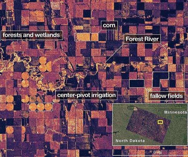
Launched by ISRO on July 30, NISAR is designed to provide unprecedented insights into natural hazards, agriculture, and climate change. Its first L-band synthetic aperture radar images, released in August, captured detailed views of Mount Desert Island in Maine and agricultural regions of North Dakota. Waterways, forests, farmland, and human structures were all distinctly visible, underscoring the system's ability to differentiate between land cover types.
"The successful capture of these first images from NISAR is a remarkable example...
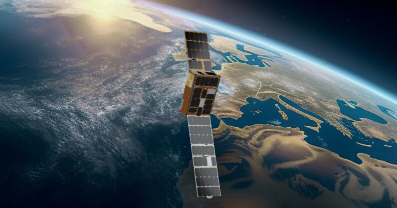
A satellite just used AI to make its own decisions in space—and NASA is stoked
For the first time, a satellite has used onboard AI to autonomously decide where and when to capture a scientific image—all in under 90 seconds, with no human input.
The technology, called Dynamic Targeting, was tested by NASA’s Jet Propulsion Laboratory (JPL) earlier this month. It was installed aboard a briefcase-sized satellite built and operated by UK-based startup Open Cosmos and carried a machine learning processor developed by Dublin-based firm Ubotica.
In the test, the satellite tilted forward to scan 500km ahead of its orbit and snapped a preview image. Ubotica’s AI quickly analysed the scene to check for cloud cover. If the skies were clear, the satellite tilted back to take a detailed photo of the surface. If clouds obscured the view, it skipped the shot—saving time, storage, and bandwidth.
“If you can be smart about what...
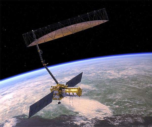
NISAR satellite to offer precise monitoring of Earth’s surface movements
Technology tamfitronics NISAR satellite to offer precise monitoring of Earth's surface movementsby Clarence OxfordLos Angeles CA (SPX) Nov 09, 2024Data from NISAR will improve our understanding of such phenomena as earthquakes, volcanoes, and landslides, as well as damage to infrastructure.Earth's surface is in a state of continuous motion, although often unnoticed. Scientists have utilized satellite and ground-based technology to observe movements linked to geological events such as earthquakes, landslides, and volcanic activity. A new initiative by NASA and the Indian Space Research Organisation (ISRO) aims to enhance this knowledge and potentially aid in disaster preparedness and recovery efforts.The NASA-ISRO Synthetic Aperture Radar (NISAR) mission is set to measure the movement of nearly all land and ice-covered regions on Earth twice within a 12-day period. This frequent data collection will offer researchers...

NRO readies open call for satellite remote sensing
Top Stories Tamfitronics Canadian Forces Station in northern Canada. Capella Space spotlight mode image acquired on Aug. 21, 2024. Credit: Capella SpaceMOUNTAIN VIEW, Calif. – The National Reconnaissance Office will invite companies to propose remote sensing capabilities on an ongoing basis.In the past, the agency responsible for designing, building and operating U.S. spy satellites has solicited proposals through Broad Area Announcements, which have defined timelines for submission and contract award.Next year, the NRO will seek proposals through a contracting mechanism called Commercial Solutions Opportunity (CSO). Through CSO, the NRO will invite companies to submit proposals for electro-optical, radar, hyperspectral and other remote sensing modalities the agency has investigated through BAAs. The NRO also is looking for new capabilities like space-based LiDAR (Light Detection and Ranging), Pete Muend, head of the NRO’s commercial space office,...


![React Native - The Practical Guide [2025]](https://img-c.udemycdn.com/course/480x270/1436092_2024_4.jpg)

